Monitoring of boats and whaleboats on the Congo River and its tributaries
In a country like the Democratic Republic of Congo, where the construction and maintenance of land roads are very expensive and devastating for our environment (deforestation, destruction of fauna and flora ...), and this, both in the tormented relief of the mountainous belt that borders the marshy central basin, the need was very quickly felt to organize more profitable, more affordable and more ecological traffic on the river.
Challenge
With more than 13,450 km of navigable waterways, the Congo River - middle section that goes from Kinshasa to Kisangani - and its tributaries represent a first choice communication channel to connect the different towns and cities of our country.
How to ensure the safety of boats of different sizes operating on the river and its tributaries by giving ship-owners the possibility of being informed in real time of the position of their boats and seafarers to inform the mainland in the event of an alert, on a river where internet and mobile phone coverage is only available along the shores of the major cities mentioned?
Solution
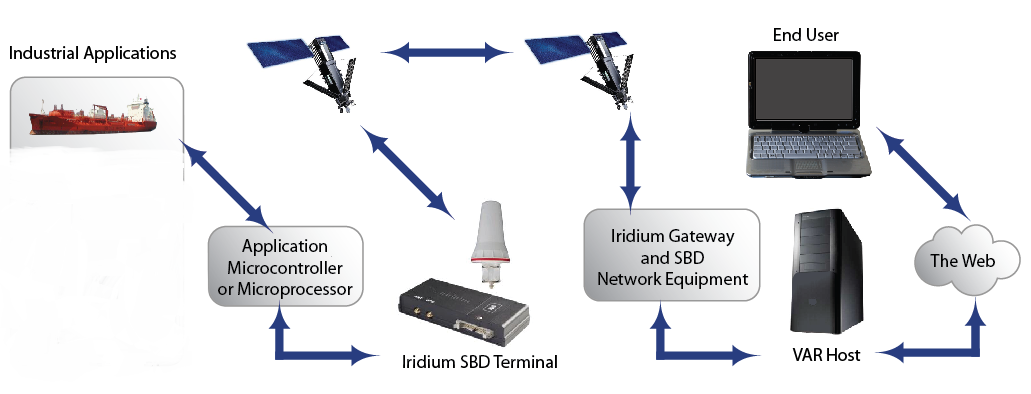
IRIDIUM satellites form a network covering the entire globe and providing low latency connectivity to monitor vessels and their contents even when GSM coverage is unavailable.
Our solution combines a GPS beacon with an IRIDIUM terminal and therefore makes it possible to know in real time the position of boats on the Congo River even in the absence of GSM coverage. In addition, in the event of a technical problem, it offers the possibility for seagoing personnel to send SOS messages alerting the ship-owner.
Topology